
Navigation using GPS while you are driving or on the commute is quick and easy with the Maps and Navigation apps. In case you are using an Android smartphone, you could make use of the Google Maps app inbuilt on your devices on the go. What if you are inside a large building and needs a map or navigation tool to explore the entire facility? The GPS or similar mechanism would not work for indoor mostly. There are certain indoor navigation apps available on the Google Play Store to help you with this.
The indoor navigational apps work different compared to the normal navigation apps. In this article, we discuss top five Android apps available today to create and use indoor maps easily, with quick tutorials.
Path Guide
The Path Guide is a plug-and-play indoor map and navigation app from Microsoft for Android users. the app is available across Android and Windows devices yet, it works perfectly on Android smartphones with GS positioning and other motion sensors. Microsoft released the app with the aim to redefine the navigation concept by not using the GPS. The mapping of the building structures are done by your motion manually.
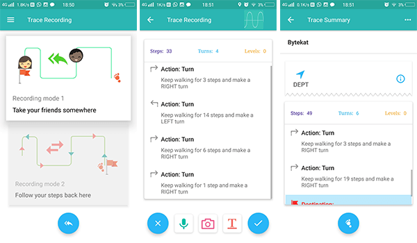

The app does not require GPS or any other positioning sensors to navigate within buildings. Microsoft Path Guide uses your smartphone’s barometer and magnetometer to calculate distances and define maps of the building you need to create indoor maps. Most smartphones only need the magnetometer or pedometers to set the directions, but the barometer helps it to identify the steps or elevations which helps in creating an accurate structure of the building. On each diversion or turning, you can add images to simplify the navigation process for the users.
Download Path Guide: PlayStore
Related: 6 Best Offline Maps for Android to Convert Android Tablet to GPS
Google Indoor Maps
Google Indoor Maps option is an inbuilt indoor navigation feature within Google Maps. The service allows users to see the buildings that have indoor maps, which are in the directory already. The Maps comprises only certain types of buildings and institutions like Airport, Bus bays, Shopping malls, stadiums, etc. Therefore, the new entries and restricted and will be approved only if the building is from any of the above categories. You can also try to mail them for indoor map adding or modification.
- North and South America: indoorpartners-americas@google.com
- Asia and the Pacific Islands: indoorpartners-apac@google.com
- Africa, Europe, and the Middle East: indoorpartners-emea@google.com
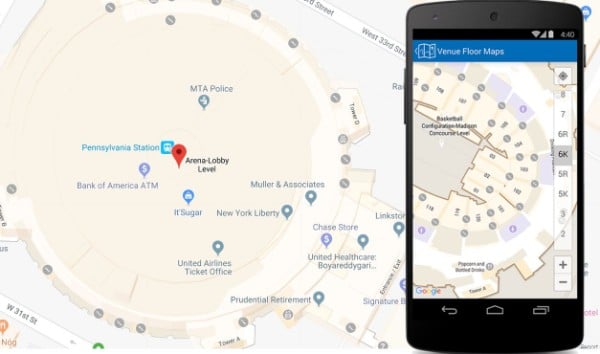

Users can search for locations with indoor maps in order to perform indoor navigation using your smartphone. When you find a building with an indoor map, you can simply zoom in and touch it to reveal the indoor navigation & map. The indoor maps will be shown in the standard Google Maps interface and no special app needed for this.
Download Google Maps: Play Store
Related: 10 Best Google Maps Navigation Tips you Must Know
Situm Mapping Tool
The Situm mapping tool is an enterprise level software tool across Operating Systems for corporate indoor navigation, mapping, and sharing. The Situm stores and shares the map of the indoor map of your building with the entire global users. You can also access other building maps from the Situm dashboard. In order to start using the app, you must go to the Situm Dashboard webpage and create an account firstly. Then you can choose any location from the map and start adding buildings.
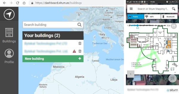

All your created locations or buildings will be visible in the Situm Mapping Tool app and you can create indoor maps for your buildings. You need to upload the floor map manually. It will be attached to your building on the entire map and there you will be able to set the navigation.
On each floor, you can choose a spot and record the pathways between locations. The app calculates the distance by movements and turnings. With the combined mean of the gyroscope, wifi, and Bluetooth, the app will accurately create indoor maps for you. The app has a tutorial section within, which could lead you through the mapping procedures.
Download Situm Mapping Tool: PlayStore
HERE Indoor Radio Mapping
You might be familiar with the HERE Maps, even back from the old-school Nokia’s Symbian phones. This app is an indoor navigation and mapping app from the HERE, but not an entire package for the public. The app comes with a demo version which they provide for free. You need to get a license in order to use the indoor maps professionally.
The HERE Indoor Radio Mapping is an easy-to-use app, and there is no complex procedure needed. Unlike Situm, you don’t need to choose the location from the map. Instead, you can add buildings and include the floor plans and perimeters to set pathways.
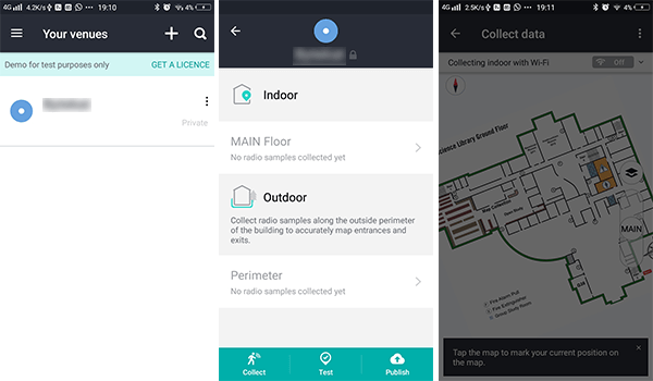
The app also sports an option to calculate the outdoor perimeters and ways. Users are required to add the floor maps for the reference. The, you can calculate and set pathways inside your building with the help of Wi-Fi or Bluetooth. Another biggest advantage is it uses SLAM mode to localize the navigation and to synchronize with the map simultaneously. After setting maps, you can test your indoor navigation before publishing it for future usage.
Download HERE Indoor Radio Mapping: PlayStore
IndoorAtlas MapCreator 2
The Map Creator from IndoorAtlas is specifically made for Indoor navigation. The creators also provide a minimal Android app to manage your maps. You need to add buildings and create maps from the IndoorAtlas website and the option is lacking the App. Steps are easy, but you need to do it on your PC.
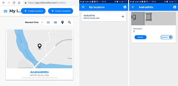

Te IndoorAtlas website directly allows any users to create a location of yours and add floor maps to it. When it comes to the manual mapping, you have to rely on the Android app and it is so quick. To record the map navigation for your indoor, there must be gyroscope on your smartphone. All other operations including edit, add a new floor, generating floors, etc. need to be done using the web dashboard of IndoorAtlas. If you are a developer, you can also create apps using the API by integrating your own maps with new projects.
Download IndoorAtlas MapCreator 2: PlayStore
Also Read: How to Share your Location without a Street Address or City?
Indoorway
The indoorway is an ultimate indoor navigation package for enterprise level consumers who want to set a proper and accurate map for their commercial buildings and publish for the public. Currently, there is no standalone application comes from the developers to record and save the indoor maps right from your smartphone. Instead, you can create maps using the Web Dashboard of Indoorway. however, you can manage and share the navigation/maps easily using the dedicated apps from the developers itself.
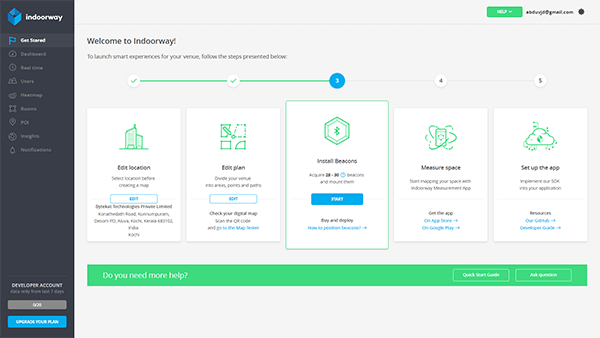

This could be the best platform for those who want to set up the indoor maps of their office buildings. The platform uses the Google business listing data to discover your business. Thus you can set up the map of your location easily. There must also be 28-30 Bluetooth beacons. This allows you to create maps with accurate height and area data. Also, helps client users to navigate easily through your building using the navigation data.
Download Indoorway: PlayStore
Above-mentioned apps are suitable if you are looking for well-structured indoor map platforms. We picked these best apps from Google Play Store after our experience of usage with them. There are also many alternate apps available on the store with a similar purpose.


